Saturday, October 4, 2014

Vijayanagar :One of the Forgotten Empire (1336–1646)

Vijayangrmap


The Vijayanagara Empire  referred to as the Kingdom of Bisnegar by the Portuguese, was an empire based in South India, in the Deccan Plateau region. It was established in 1336 by Harihara I and his brother Bukka Raya I of Sangama Dynasty. The empire rose to prominence as a culmination of attempts by the southern powers to ward off Islamic invasions by the end of the 13th century. It lasted until 1646 although its power declined after a major military defeat in 1565 by the Deccan sultanates. The empire is named after its capital city of Vijayanagara, whose ruins surround present day Hampi, now a World Heritage Site in Karnataka, India.The writings of medieval European travelers such as Domingo Paes, Fernão Nunes and Niccolò Da Conti, and the literature in local languages provide crucial information about its history. Archaeological excavations at Vijayanagara have revealed the empire's power and wealth.


vijayanagar-royal

The empire's legacy includes many monuments spread over South India, the best known of which is the group at Hampi. The previous temple building traditions in South India came together in the Vijayanagara Architecture style. The mingling of all faiths and vernaculars inspired architectural innovation of Hindu temple construction, first in the Deccan and later in the Dravidian idioms using the local granite. Efficient administration and vigorous overseas trade brought new technologies such as water management systems for irrigation. The empire's patronage enabled fine arts and literature to reach new heights in Kannada, Telugu, Tamil and Sanskrit, while Carnatic music evolved into its current form. The Vijayanagara Empire created an epoch in South Indian history that transcended regionalism by promoting Hinduism as a unifying factor.

Brief History of the Vijayanagar empire

Differing theories have been proposed regarding the Vijayanagara empire's origins. Many historians propose Harihara I and Bukka, the founders of the empire, were Kannadigas and commanders in the army of the Hoysala Empire stationed in the Tungabhadra region to ward off Muslim invasions from the Northern India. Others claim that they were Telugu people first associated with the Kakatiya Kingdom who took control of the northern parts of the Hoysala Empire during its decline. Irrespective of their origin, historians agree the founders were supported and inspired by Vidyaranya, a saint at the Sringeri monastery to fight the Muslim invasion of South India. Writings by foreign travelers during the late medieval era combined with recent excavations in the Vijayanagara principality have uncovered much-needed information about the empire's history, fortifications, scientific developments and architectural innovations.

Before the early 14th-century rise of the Vijayanagara Empire, the Hindu states of the Deccan, the Yadava Empire of Devagiri, the Kakatiya dynasty of Warangal, the Pandyan Empire of Madurai, and the tiny kingdom of Kampili had been repeatedly invaded by Muslims from the north, and by 1336 they had all been defeated by Alla-ud-din Khilji and Muhammad bin Tughluq, the Sultans of Delhi. The Hoysala Empire was the sole remaining Hindu state in the path of the Muslim invasion. After the death of Hoysala king Veera Ballala III during a battle against the Sultan of Madurai in 1343, the Hoysala Empire merged with the growing Vijayanagara empire.

In the first two decades after the founding of the empire, Harihara I gained control over most of the area south of the Tungabhadra river and earned the title of Purvapaschima Samudradhishavara ("master of the eastern and western seas"). By 1374 Bukka Raya I, successor to Harihara I, had defeated the chiefdom of Arcot, the Reddys of Kondavidu, the Sultan of Madurai and gained control over Goa in the west and the Tungabhadra-Krishna River doab in the north. The original capital was in the principality of Anegondi on the northern banks of the Tungabhadra River in today's Karnataka. It was later moved to nearby Vijayanagara on the river's southern banks during the reign of Bukka Raya I.

With the Vijayanagara Kingdom now imperial in stature, Harihara II, the second son of Bukka Raya I, further consolidated the kingdom beyond the Krishna River and brought the whole of South India under the Vijayanagara umbrella.The next ruler, Deva Raya I, emerged successful against the Gajapatis of Odisha and undertook important works of fortification and irrigation. Italian traveler Niccolo de Conti wrote of him as the most powerful ruler of India. Deva Raya II (called Gajabetekara) succeeded to the throne in 1424 and was possibly the most capable of the Sangama dynasty rulers. He quelled rebelling feudal lords as well as the Zamorin of Calicut and Quilon in the south. He invaded the island of Lanka and became overlord of the kings of Burma at Pegu and Tanasserim. The empire declined in the late 15th century until the serious attempts by commander Saluva Narasimha Deva Raya in 1485 and by general Tuluva Narasa Nayaka in 1491 to reconsolidate the empire.


KrishnaDevaraya


After nearly two decades of conflict with rebellious chieftains, the empire eventually came under the rule of Krishna Deva Raya, the son of Tuluva Narasa Nayaka. In the following decades the Vijayanagara empire dominated all of Southern India and fought off invasions from the five established Deccan Sultanates. The empire reached its peak during the rule of Krishna Deva Raya when Vijayanagara armies were consistently victorious. The empire annexed areas formerly under the Sultanates in the northern Deccan and the territories in the eastern Deccan, including Kalinga, while simultaneously maintaining control over all its subordinates in the south. Many important monuments were either completed or commissioned during the time of Krishna Deva Raya.

Krishna Deva Raya was followed by his younger half-brother Achyuta Deva Raya in 1529. When Achyuta Deva Raya died in 1542, Sadashiva Raya, the teenage nephew of Achyuta Raya was appointed king though real power was wielded by Rama Raya, Krishna Deva Raya's son-in-law. When Sadashiva was old enough to claim absolute power, Aliya Rama Raya had him imprisoned and became the de facto ruler. Eager to take advantage of the disunity among the Sultanates of Bijapur, Ahamednagar, Berar, Golkonda, and Bidar, Rama Raya involved himself in the political affairs of the powers across the Krishna river to the north. His ploy of supporting militarily one Sultanate against another, often changing alliances, brought rich rewards for a while. However, by 1563, exhausted with his intrigues, the bitter rivals from the north formed an alliance. They marched against Rama Raya and clashed with the Vijayanagara's forces in January 1565.The capture and killing of Aliya Rama Raya in the famous Battle of Talikota, after a seemingly easy victory for the Vijayanagara armies, created havoc and confusion in the Vijayanagara ranks, which were then completely routed. The Sultanates' army later plundered Hampi and reduced it to the ruinous state in which it remains; it was never re-occupied. Tirumala Deva Raya, Rama Raya's younger brother who was the sole surviving commander, left Vijayanagara for Penukonda with vast amounts of treasure on the back of 1500 elephants.

The empire went into a slow decline regionally, although trade with the Portuguese continued, and the British were given a land grant for the establishment of Madras.Tirumala Deva Raya was succeeded by his son Sriranga I later followed by Venkata II who was the last king of Vijayanagara empire, made his capital Chandragiri and Vellore, repulsed the invasion of the Deccan Sultanates and saved Penukonda from being captured.
His successor Rama Deva Raya took power and ruled until 1632, after whose death Venkata III became king and ruled for about ten years. The empire was finally conquered by the Sultanates of Bijapur and Golkonda. The largest feudatories of the Vijayanagar empire – the Mysore Kingdom, Keladi Nayaka, Nayaks of Madurai, Nayaks of Tanjore, Nayakas of Chitradurga and Nayak Kingdom of Gingee declared independence and went on to have a significant impact on the history of South India in the coming centuries. These Nayaka kingdoms lasted into the 18th century while the Mysore Kingdom remained a princely state until Indian Independence in 1947 although they came under the British Raj in 1799 after the death of Tipu Sultan.

Race over the Frequency

old1 radio

Indian Radio History

In British India, broadcasting began in July 1923 with programmes by the Radio Club of Bombay and other radio clubs. According to an agreement of 23 July 1927, the private Indian Broadcasting Company LTD (IBC) was authorized to operate two radio stations; the Bombay station began on 23 July 1927, and the Calcutta station followed on 26 August 1927. On 1 March 1930, however, the company went into liquidation. The government took over the broadcasting facilities, beginning the Indian State Broadcasting Service (ISBS) on 1 April 1930 (on an experimental basis for two years, and permanently in May 1932). On 8 June 1936; the ISBS was renamed All India Radio.

On 1 October 1939 the External Service began with a broadcast in Pushtu; it was intended to counter radio propaganda from Germany directed to Afghanistan, Iran and the Arab nations. When India became independent in 1947, the AIR network had only six stations (in Delhi, Bombay, Calcutta, Chennai, Lucknow, and Tiruchirappalli); the total number of radio sets at that time was about 275,000. On 3 October 1957 the Vividh Bharati Service was launched, to compete with Radio Ceylon. Television broadcasting began in Delhi in 1959 as part of AIR, but was split off from the radio network as Doordarshan on 1 April 1976.FM broadcasting began on 23 July 1977 in Chennai, and was expanded during the 1990s.

1092892_2b5f7c48

The word "Akashvani" was coined by M. V. Gopalaswamy after setting up the nation’s first private radio station in his residence, "Vittal Vihar" (about 200 yards from AIR’s current location in Mysore) in 1936. Akashvani means "celestial announcement"; the word, of Sanskrit origin, is often found in Hindu mythology. When the gods wished to say something, an akashvani occurred. Literally, akash means "sky" and vani means "sound" or "message". Thus, Akashvani seemed to be fit for use by a radio broadcaster and was later adopted as All India Radio's on-air name after independence.


Focus on Tamil-Nadu

Radio stations that broadcast in the Tamil language are found primarily in India, Sri Lanka, Malaysia, United Kingdom, United States, South Africa, Canada as well as other parts of the world containing a significant Tamil diaspora population.But race for frequency has recently started about a decades putting down the old AIR down and attracting listeners with new ideas and information 

All_India_Radio_Social_Media

Key Players in Tamil radio Industry

1.Suryan FM (93.5 FM) (Chennai, Trichy, Coimbatore, Madurai, Tirunelveli, Tuticorin, Pondicherry).

Sun TV Network owns two Radio brands: Suryan FM in Tamil Nadu and for other territories Red FM. Sun is one of the largest Radio broadcasters in India and Tamil's first private FM stations

artworks-000080061624-t3sej6-crop


2.Radio Mirchi (98.3 FM) (Chennai, Coimbatore, Madurai)

Radio Mirchi is a nationwide network of private FM radio stations in India. It is owned by the Entertainment Network India Ltd (ENIL), which is one of the subsidiaries of The Times Group. The tagline of Radio Mirchi is "Idhu semmma hot machchi ,It's hot!".


radio-mirchi-300x300

3.Hello FM (106.4 FM) (Chennai, Coimbatore, Madurai, Tiruchirapalli, Tirunelveli, Tuticorin)

Hello FM (106.4 MHz) is one of the private radio stations operating from different locations in Tamil Nadu. It is owned by Malar publications, Chennai. It is licensed to use the FM band frequency 106.4 MHz. It started in 2006 broadcasting from Chennai and Coimbatore. Later, in 2007 it expanded its broadcast to other cities in Tamil Nadu such as Madurai, Trichy, Tirunelveli, Tuticorin and to the union territory of Puducherry.


4.Radio City (91.1 FM) (Chennai, Coimbatore)
5.Aahaa FM (91.9 FM) (Chennai)
6.Big FM (92.7 FM) (Chennai)
7.Radio One (94.3 FM) (English) (Chennai)

Friday, October 3, 2014

Kamakhya Temple

The Kamakhya Temple  is a Hindu temple dedicated to the mother goddess Kamakhya, one of the oldest of the 51 Shakti Pitha.s, Situated on the Nilachal Hill in western part of Guwahati city in Assam, India it is the main temple in a complex of individual temples dedicated to the ten Mahavidyas: Bhuvaneshvari, Bagalamukhi, Chinnamasta, Tripura Sundari, Tara, Kali, Bhairavi, Dhumavati, Matangi and Kamala. Among these, Tripurasundari, Matangi and Kamala reside inside the main temple whereas the other seven reside in individual temples. It is an important pilgrimage destination for general Hindu and especially for Tantric worshipers.


History

Ancient

The earliest historical dynasty of Kamarupa, the Varmans (350-650), as well as Xuanzang, a 7th-century Chinese traveler ignore the Kamakhya, when it is assumed that the worship was Kirata-based beyond the brahminical ambit. The first epigraphic notice of Kamakhya is found in the 9th-century Tezpur plates of Vanamalavarmadeva of the Mlechchha dynasty. There is enough archaeological evidence of a massive 8th-9th century temple.


The Kamarupa kings from Indra Pala to Dharma Pala were followers of the Tantrik tenet and about that period Kamakhya had become an important seat of Tantrikism. The Kamarupa kings, after Brahma Pala, adopted Tantrikism as their tenet and, as a result of this royal patronage, Kamakhya soon became a renowned centre of Tantrik sacrifices, mysticism and sorcery. That system of mystic Buddhism, known as Vajrayana and popularly called the "Sahajia cult", found its way into Kamarupa as early as the tenth century, is corroborated from an unexpected source. It is found from Tibetan records that some of the eminent Buddhist professors in Tibet, of the tenth and the eleventh centuries, hailed from Kamarupa. The Kalika Purana, a well-known work, gives the Sanskritized names of most of the rivers and hills of Brahmaputra valley. It gives a full account of the Naraka legend and the old city of Pragjyotishpura. It dwells upon the special merit and sanctity of the shrine of Kamakhya.

Medieval

There is a tradition that the temple was destroyed by Kalapahar, a general of Sulaiman Karrani (1566–1572), though the latest historical findings favor instead an earlier destruction during Hussein Shah's invasion of the Kamata kingdom (1498) then under Nilambar. The ruins of the temple was said to have been discovered by Vishwasingha, the founder of the Koch dynasty, who revived worship at the site; but it was during the reign of his son, Naranarayan, that the temple reconstruction was completed in 1565. The reconstruction used material from the original temples that was lying scattered about. Banerji (1925) records that this structure was further built over by the rulers of the Ahom kingdom. Many other structures are yet later additions.

The current structure has been built during the Ahom times, with remnants of the earlier Koch temple carefully preserved.Temple was destroyed during the middle of second millennium and revised temple structure was constructed in 1565 by Chilarai of the Koch dynasty in the style of medieval temples.

According to a legend the Koch Bihar royal family was banned by Devi herself from offering puja at the temple. In fear of this curse, to this day no descendants of that family dares to even look upward towards the Kamakhya hill while passing by. Without the support of the Koch royal family the temple faced lot of hardship. By the end of 1658, the Ahoms under king Jayadhvaj Singha had conquered the Kamrup and their interests in the temple grew. In the decades that followed the Ahom kings, all who were either devout Shaivite or Shakta continued to support the temple by rebuilding and renovating it.

Rudra Singha (reign 1696 to 1714) was a devout Hindu and as he grew older he decided to formally embrace the religion and become an orthodox Hindu by being initiated or taking sharan of a Guru, who would teach him the mantras and become his spiritual guide. But, he could not bear the thought of humbling himself in front of a Brahmin who is his subject. He therefore sent envoys to Bengal and summoned Krishnaram Bhattacharyya, a famous mahant of Shakta sect who lived in Malipota, near Santipur in Nadia district. The mahant was unwilling to come, but consented on being promised to be given the care of the Kamakhya temple to him. Though the king did not take sharan, he satisfied the mahant by ordering his sons and the Brahmins in his entourage to accept him as their spiritual guru.

When Rudra Singha died, his eldest son Siba Singha (reign 1714 to 1744), who became the king, gave the management of the Kamakhya temple and along with it large areas of land (Debottar land) to Mahant Krishnaram Bhattacharyya. The Mahant and his successors came to be known as Parbatiya Gosains, as they resided on top of the Nilachal hill. Many Kamakhya priests and modern Saktas of Assam are either disciples or descendants of the Parbatiya Gosains, or of the Nati and Na Gosains.


Worship

It is likely that this is an ancient Khasi sacrificial site, and worshiping here still includes sacrifices. Devotees come every morning with goats to offer to Shakti.The Kalika Purana, an ancient work in Sanskrit describes Kamakhya as the yielder of all desires, the young bride of Shiva, and the giver of salvation.Shakti is known as Kamakhya.


The first tantric Kamakhya Temple was destroyed during the Mongol invasion in the Nilachal hills in the 12 BC, so was the fate of the second tantric temple destroyed in the Muslim attacks, probably by the Hindu convert Muslim warrior 'Kala Pahad'. The Brahaminical legend of the 'Shakti' in the later period led to the worship of the tantric goddess as Hindu 'Shakti' goddess. The worship of all female deity in Assam symbolizes the "fusion of faiths and practices" of Aryan and non-Aryan elements in Assam. The different names associated with the goddess are names of local Aryan and non-Aryan goddesses. The Yogini Tantra mentions that the religion of the Yogini Pitha is of Kirata origin.According to Banikanta Kakati, there existed a tradition among the priests established by Naranarayana that the Garos, a matrilineal people, offered worship at the earlier Kamakhya site by sacrificing pigs.


The goddess is worshiped according to both the Vamachara (Left-Hand Path) as well as the Dakshinachara (Right-Hand Path) modes of worship. Offerings to the goddess are usually flowers, but might include animal sacrifices. In general female animals are exempt from sacrifice, a rule that is relaxed during mass sacrifices.


River Styx :Gate way between underworld & earth

The river of which many know its name, without knowing its origin or what it really stood for. A river that separates the world of the living from the world of the dead. Styx it is said winds around Hades (hell or the underworld are other names) nine times. Its name comes from the Greek word stugein which means hate, Styx, the river of hate. This river was so respected by the gods of Greek mythology that they would take life binding oaths just by mentioning its name, as referenced in the story of Bacchus-Ariadne, where Jove "confirms it with the irrevocable oath, attesting the river Styx."
Charon ferried the souls of the dead across the Styx.


There are five rivers that separate Hades from the world of the living, they are:
1.Acheron - the river of woe;
2.Cocytus - the river of lamentation;
3.Phlegethon - the river of fire;
4.Lethe - the river of forgetfulness;
5.Styx - the river of hate.


It is thought that Charon, the old ferry man who ferries the dead onto the underworld, crosses the river Styx where the dragon tailed dog Cerberus guards, allowing all souls to enter but none to leave. This is a misconception, Charon crosses the river Acheron where also Cerebus stands his eternal guard. Also while on this subject, Charon only takes the souls across that are buried properly with a coin (called an obol) that was placed in their mouths upon burial.
If a god gave his oath upon the river Styx and failed to keep his word, Zeus forced that god to drink from the river itself. The water is said to be so foul that the god would lose his/her voice for years. The river is not the subject of any story itself but is mentioned in several. These little pieces give a wonderful view of not only the river but the ancient Greeks view of the underworld. From its Adamantine gates to its separate levels of Tartarus and Erebus onto the Elysian fields.


Legend or Facts??

These symptoms are eerily similar to those suffered by Alexander the Great before his premature death due to an unidentified sudden illness in 323 B.C. The Greek leader suffered stabbing pains in his internal organs and joints, high fever, and voice loss before he slipped into a coma.Those symptoms are also very similar to those experienced by a person who has ingested calicheamicin, a toxin produced by bacteria found in limestone, which is found in high concentrations in the Mavroneri River. Also known as Black Water, the river flows out of the Peloponnesian mountains and has long been thought to be the real-world entrance to the River Styx. Ancient tradition states that the water was so corrosive and so deadly, like its mythical counterpart, that the only things it couldn’t dissolve were a boat and raft made from horse hooves.If the theory about Alexander the Great is true, it suggests that he died not from malaria or typhoid, as previously suspected, but that he was poisoned by someone who had taken water from the mythical River Styx.

Punta Cruz Watch Tower

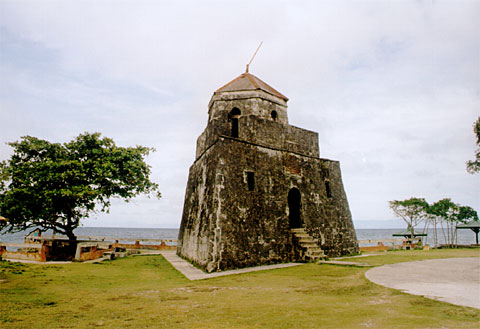
In Maribojoc, some 14 km west of Tagbilaran City, a curious triangular watch tower oversees the seas South of Bohol. From its windows at the top, you can see Cebu, Siquijor, and Mindanao. The Spanish had it build in 1796 as a look-out post against pirates and Muslim marauders, who at that time where a plague to the people of Bohol.


Remants of similar triangular towers can be found in a number of other places along the coast of Bohol, such as Panglao, Dauis, Loay, and on Pamilacan island, but this tower is the most intact. The tower of Loay, about 18 km east of Tagbilaran is much eroded by the waves of the sea. The tower on Pamilacan island was build to a slightly different plan.
Castillo Des Vicen 11 Ferrer Cuesta Punta dela Cruzanon Ulo y Arbeldela de los Espańoles Hasta Hoy y fe Venera ensu Pueblo de Maribohoc con Devocion del Santo Vi a Crucis Ańo 1796
Translations of the inscriptions of Punta Cruz Watchtower at the Entrance of the Tower
“Castillo De San Vicente Ferrer in this Punta Cruz, whose title and tree of the Holy Cross from the conquest of the Spaniards until now, is venerated in this town of Malabojoc, with the veneration of the Holy via crucis year 1796.
Today the Punta Cruz watch tower still provides an excellent view. The site now offers a small stall for buying drinks and snacks and makes a good spot for a picnic and a swim -- although you'll have to watch out when you climb on the very sharp rocks.


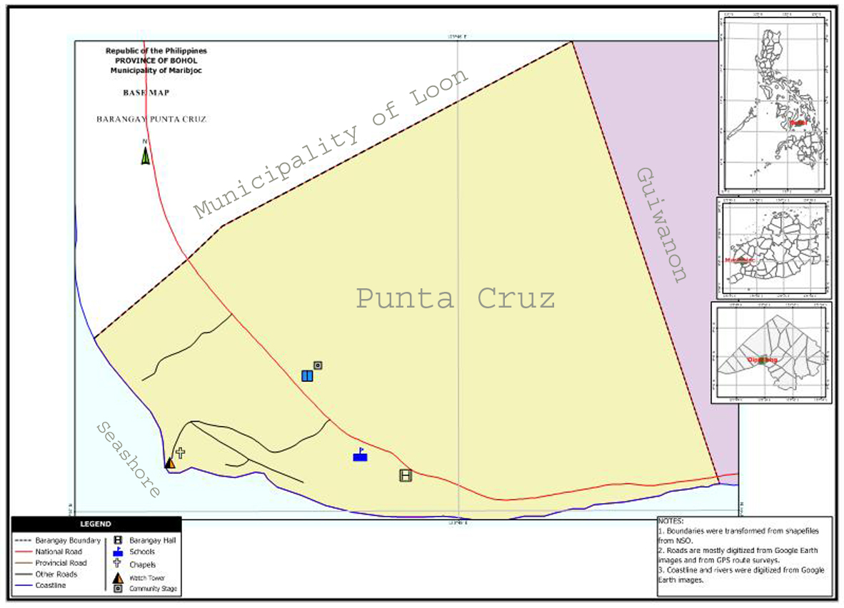
Getting there. Catch a bus at the Tagbilaran Integrated Bus Terminal in Dao. Most buses going in to Tubigon will pass along Punta Cruz. Ask the driver to drop you off at Punta Cruz, and walk down for about 500 meters to the watch tower. Located at the western tip of Maribojoc. The popular name of Barangay Punta Cruz is derived from the” Punta” which means  cape  and the word Punta Cruz was coined from the cross which was planted on the said place to scare the Moro marauders. The original and extinct name of the place is Guimnay where a spring is located serving the inhabitants as its water source. Built in 1796, the only perfect isosceles triangle tower-the only structure so formed in the country.
This was dedicated to San Vicente Ferrer, the Punta Cruz watchtower on the shores of the municipality of Maribojoc served as the lookout for incoming pirates. It was part of a wider defense net build along the Visayan coast to protect settlements from slave raiding moros that struck during the season of the southwestern monsoon. It commands an excellent view of Bohol Strait and the neighboring island of Cebu.


The upper floor of the tower offers a breathtaking view of the sea facing the provinces of Cebu, Siquijor and Mindanao. As one enters the tower, you will be welcomed by the image of St. Vincent Ferrer to whom this tower was dedicated. Beside the tower is a wooden cross that stands in a rock clip that sticks out into the sea. Townsfolk believe that the wooden cross is mysterious and believed to protect the island from the invasion from the cruel Moro pirates. Legend has it that whenever the pirates try to attack the province, a glaring light emanates from the wooden cross causing fear and difficulties for the pirates to sight the land.


Laguna del Mauleh

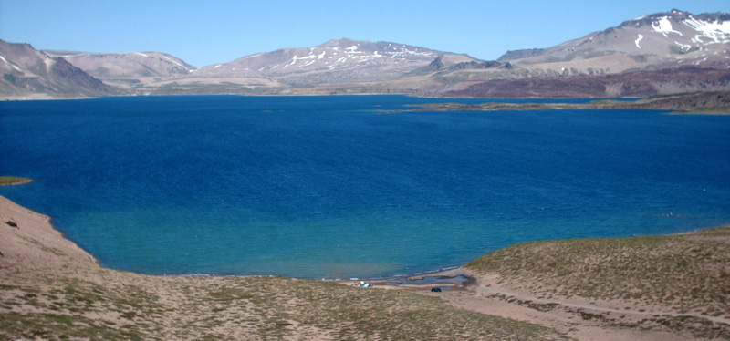
Laguna del Maule Volcanic Complex is a caldera measuring 15 km by 25 km over which sit several small stratovolcanoeslava domes, and pyroclastic cones. Within the caldera is Laguna del Maule, which gives origin to the Maule River.


The volcanic complex is located mainly in Chile with a small portion lying in Argentina.


Mauna Loa : One of the Largest Super Volcanoes ever!!

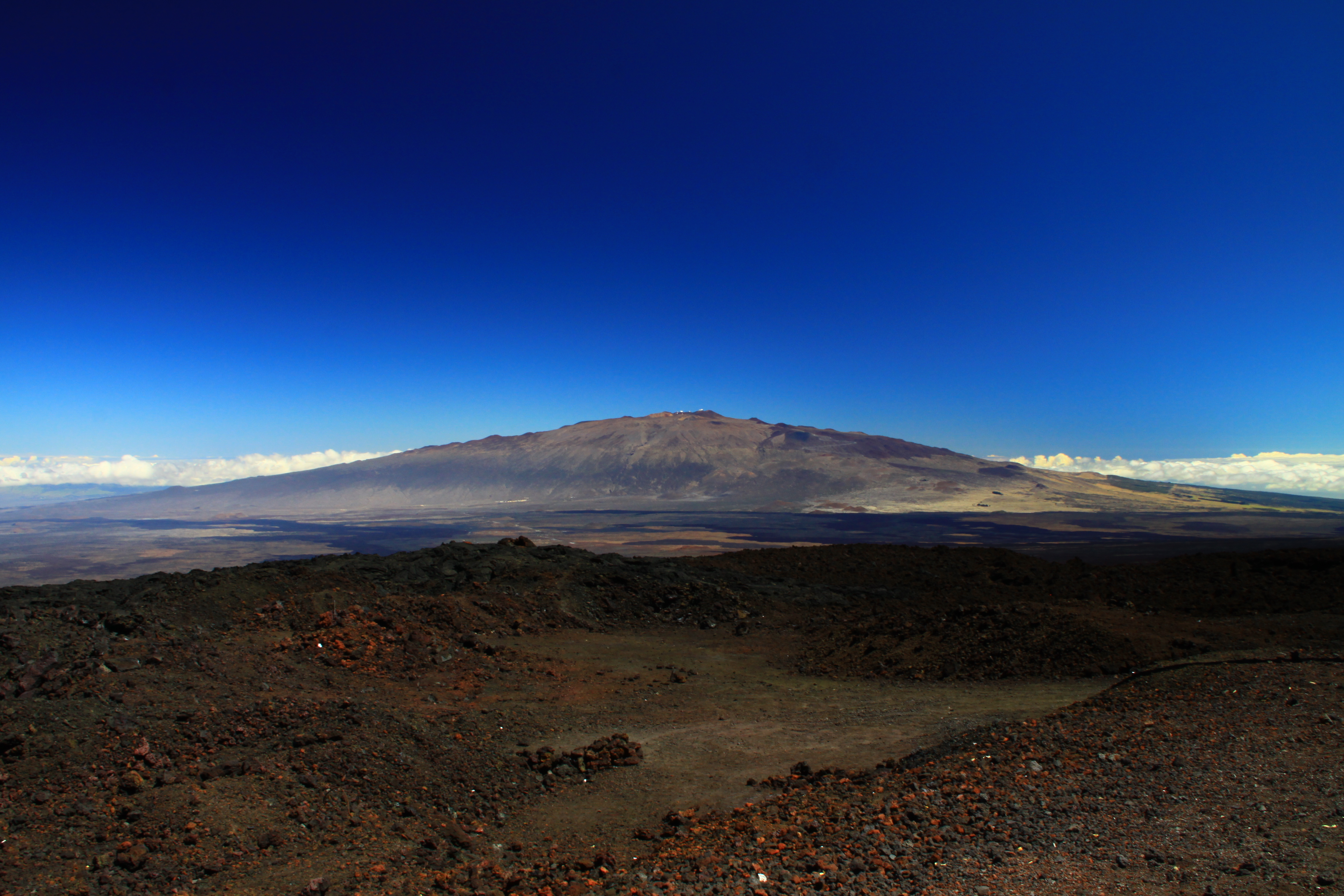
Mauna Loa is one of five volcanoes that form the Island of Hawaii in the U.S. state of Hawaiʻi in the Pacific Ocean. Mauna Loa is the largest subaerial volcano in both mass and volume, and has historically been considered the largest volcano on Earth. It is an active shield volcano, with a volume estimated at approximately 18,000 cubic miles (75,000 km3), although its peak is about 120 feet (37 m) lower than that of its neighbor, Mauna Kea. The Hawaiian name "Mauna Loa" means "Long Mountain". Lava eruptions from Mauna Loa are silica-poor, and very fluid; eruptions tend to be non-explosive and the volcano has relatively shallow slopes.


Mauna Loa has probably been erupting for at least 700,000 years, and may have emerged above sea level about 400,000 years ago. The oldest-known dated rocks are not older than 200,000 years. The volcano's magma comes from the Hawaii hotspot, which has been responsible for the creation of the Hawaiian island chain over tens of millions of years. The slow drift of the Pacific Plate will eventually carry Mauna Loa away from the hotspot within 500,000 to one million years from now, at which point it will become extinct.

Mauna Loa's most recent eruption occurred from March 24 to April 15, 1984. No recent eruptions of the volcano have caused fatalities, but eruptions in 1926 and 1950 destroyed villages, and the city of Hilo is partly built on lava flows from the late 19th century. Because of the potential hazards it poses to population centers, Mauna Loa is part of the Decade Volcanoes program, which encourages studies of the world's most dangerous volcanoes. Mauna Loa has been monitored intensively by the Hawaiian Volcano Observatory since 1912. Observations of the atmosphere are undertaken at the Mauna Loa Observatory, and of the Sun at the Mauna Loa Solar Observatory, both located near the mountain's summit. Hawaii Volcanoes National Park covers the summit and the southeastern flank of the volcano, and also incorporates Kīlauea, a separate volcano.